Habitat surveys

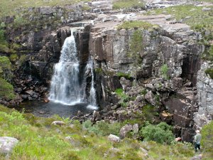
The productive area accessible to salmon and sea trout is limited in many river systems in Wester Ross by impassable waterfalls like this one above Talladale (River Ewe system)
The suitability of any stretch of water for fish production depends very much upon the quality of habitats therein. Different species of fish have different habitat requirements. Small fish are able to hide from predators in the streambed if there are suitable voids between stones. Larger fish usually require deep water, though even an adult sea trout or salmon may seek somewhere to hide between boulders where available. Growth and production of juvenile fish is also dependent upon a food supply. In Wester Ross, many streams are infertile; production of fish and other wildlife is limited by the availability of nutrients, especially phosphorus, P.
WRFT field biologists have surveyed many hundreds of km of riverbank since 1999. An SFCC protocol forms the basis of surveys. Rivers and streams are surveyed section by section. Data is recorded to describe the dimensions (length and width), depth, flow type (pool, glide, run, riffle, etc.), substrate composition (silt, sand, pebbles, cobbles, boulders, bedrock, etc.) and stability of the section, and to describe the river bank and nearby land. Photographs are taken and sketches made to highlight features of concern to fisheries.
More recently, indicators of fertility and food supply have also been recorded. These include the diversity and relative abundance of invertebrates, both in the water and on nearby river banks. Moles are indicators of healthy earthworm populations which are found where soils are healthy. In some parts of Wester Ross, New Zealand Flatworms have reduced earthworm populations to levels where moles are no longer able to find enough food. So WRFT field teams note the presence / absence of moles, New Zealand flatworms, Alder trees and an increasing list of other things. It's all about making the most of time in the field (especially if working in a remote area) and gaining some understanding of the big picture.

River Habitat Surveys in Wester Ross have been supported with grant funding from the Landfill Tax Credit Scheme.
Related Downloads
To download a file, right-click over it's name and choose Save Link/Target As...
-
Catchment vegetation, hummocks and wild salmon habitat resilience
Presentation by Peter Cunningham about project to protect salmon habitat in the Ullapool River focussing on restoration of vegetation and ecosystem fertility in the upper catchment (Glen Douchary) with examples of hummocks from other parts of Wester Ross and poster. From Catchment Vegetation Revival Workshop, Kinlochewe 26th April 2023. Posted: 02/05/2023 (23.52MB) -
Catchment vegetation workshop introduction and field trip report
Introduction to the WRFT Catchment Vegetation Revival meeting at Kinlochewe on 26th April 2023 and report from field trip to view hummocks and Donald McVean's fertilised plots by the Pony Path on Beinn Eighe NNR on 25th April 2023 by Dr Shraveena Venkatesh. Posted: 02/05/2023 (6.28MB) -
Little Loch Broom BRUV Surveys 2022
Presentation by Dr Neil Hopkins and Dr Charlotte Hopkins describing animal movements in relation to seascapes and underwater habitats from baited underwater remote video survey of Gruinard Bay and Little Loch Broom in 2022, shown at Wester Ross MPA Discovery Day on 14th October 2022. Screenshots have been taken from video clips presented to illustrate animal diversity recorded. . Posted: 08/11/2022 (1.47MB) -
Maerl biodiversity and carbon poster
Maerl, often referred to as coral by former herring fishermen, is the most important priority marine feature for which the Wester Ross Marine Protected Area was desgnated. Maerl seabed habitats provide homes for many animals including spawning herring, juvenile cod and scallops. Maerl beds around Wester Ross are some of the most important in Europe but remain inadequately surveyed. They are damaged by scallop dredging and organic nutrient rich waste discharges from open cage salmon farms. Posted: 30/05/2022 (901KB)